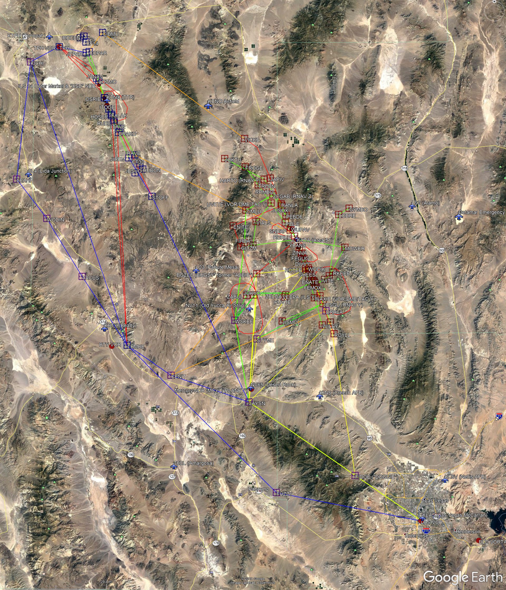
Overview of the routes: KLAS->Area 51: green, Area 51->KLAS: yellow, KLAS-TTR blue, Area 51->TTR: brown
Click here for a Google Earth plug-in with all Janet routes from Las Vegas International to Area 51 and to TTR. The file includes all fixes used by these routes as well as many other verified fixes and air fields inside the Nevada Test and Training Range (NTTR). Click on the previews below for a larger map. Scroll down for more information on the various routes and fixes.
Overview of the routes: KLAS->Area 51: green, Area 51->KLAS: yellow, KLAS-TTR blue, Area 51->TTR: brown
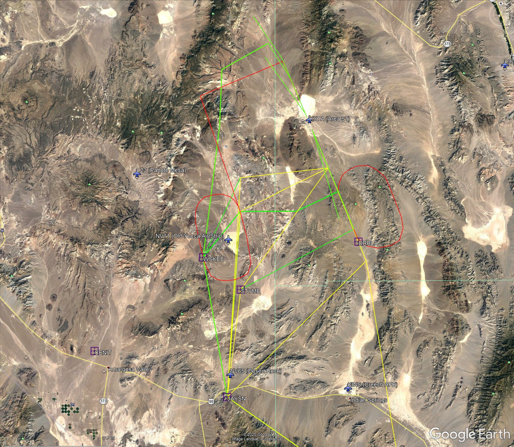
Close-up of the routes to Area 51 from the main Range entry point JAYSN; the red lines are the RNAV go-around and hold patterns
The coordinates of the no-fly zone (even for military aircraft) around Area 51, also known as "the Box" or "the Container" are:
| NW Corner | 37-28-00N / 116-00-03W |
| NE Corner | 37-28-00N / 115-35-03W |
| SE Corner | 37-06-00N / 115-35-03W |
| SW Corner | 37-06-00N / 116-00-03W |
Route: Las Vegas (KLAS) -> Area 51 (KXTA)
| Rwy 32 visual approach via WSKEE, BGZEE; most common route | KLAS-FIDOE-JAYSN-WSKEE-BGZEE-Visual 32 |
| Rwy 32 RNAV approach via WSKEE, BGZEE; common route | KLAS-FIDOE-JAYSN-WSKEE-BGZEE-RNAV 32 |
| Rwy 32 visual approach via BGZEE; common route, shortcut over Yucca Lake | KLAS-FIDOE-JAYSN-BGZEE-Visual 32 |
| Rwy 32 ILS X (ILS Z?) approach; sometimes used by the Beech Janets | KLAS-FIDOE-JAYSN-WSKEE-BGZEE-HOMEY (cross over field)-ILS X 32 |
| Janets from TTR | BTY-SSKUL-BGZEE-Visual 32 |
| Direct route, early or late Janets when Range 64A-C and 65A are cold | KLAS-FIDOE-SMKEE-ILS Y 32 |
| Sometimes used by early or late Janets when Range 65A is cold | KLAS-FIDOE-JAYSN-WSKEE-JOKVO-RNAV Z 32 |
| Route via Range 65B when keyhole is in effect | KLAS-FIDOE-JAYSN-STYME-DRRLA-Visual 32 |
| Shortcut to the above, sometimes available when keyhole is in effect | KLAS-FIDOE-JAYSN-STYME-Visual 32 |
| Shortcut, sometimes used when keyhole is in effect | KLAS-FIDOE-JAYSN-SMKEE-ILS Y 32 |
| Rwy 14 visual approach | KLAS-FIDOE-JAYSN-GITZM-Visual 14 |
| Rwy 14 visual approach via WSKEE | KLAS-FIDOE-JAYSN-WSKEE-GITZM-Visual 14 |
| Rwy 14 RNAV approach via WSKEE | KLAS-FIDOE-JAYSN-WSKEE-GITZM-RNAV Z 14 |
Route: Area 51 (KXTA) -> Las Vegas (KLAS)
| Normal route when Ranges 65A-C are hot | RNAV 14 Dep-BGZEE-JAYSN-FIDOE-KLAS |
| Shortcut if Ranges 65A and 65B are cold | RNAV 14 Dep-STYME-JAYSN-FIDOE-KLAS |
| Direct route, early or late Janets when Range 64A-C and 65A are cold | RNAV 14 Dep-ROYLL-FIDOE-KLAS |
Janets typically use Area 51 Rwy 32 to land and Rwy 14 to take off. This results in a more direct route and thus shorter flight time to Las Vegas. Rwy 32 is equipped with an ILS. Both runways 14 and 32 have associated waypoints for an RNAV approach. In Las Vegas Janets mostly use runways 1/19 (L or R) if weather conditions permit because those runways are located close to the Janet terminal.
The filed flight plans for flights to and from Area 51 are always the same. Flight TO Area 51 (inbound) list the EXITT fix as the last waypoint. Flights FROM Area 51 (outbound) list EXITT as the first waypoint. In reality Janets to and from Area 51 never even use the EXITT fix.
Most inbound flights divert from the filed flight plan after entering the restricted air space over Mercury, after passing the JAYSN fix and hand-off to Area 51 Approach Control. From here Janets take one of several routes (see maps above), depending on conditions in the live fire ranges and in the Nevada National Security Site (NNSS). While Keyhole is in effect and when the 60's ranges are cold inbound Janets sometimes take a shortcut, referred to as "direct". This leads north from FIDOE over Creech AFB and to the SMKEE fix for an ILS approach to runway 32.
Outbound flights follow similar routes in reverse order of waypoints.
Inbound Janets are typically handed off to Area 51 Approach/Departure Control ("Control") before they enter restricted airspace. At that time they change their callsign from Janet to the Area 51 "callsign of the day" (see Janet Flight Schedule). The handoff to Area 51 Tower ("Tower") is usually near the BGZEE or JOKVO fix. Outbound flights are handled similar, in reverse order. Both Area 51 Control and Tower use unpublished VHF frequencies.
The most common routes go north from Mercury to the WSKEE fix west of the DAF. From there several routes exist to accommodate activities in the 60's Ranges. During Red Flag and when the ranges are hot the BGZEE ("Bugsy") fix is used to keep traffic out of the 60's Ranges altogether. This fix was previously referred to as "Abbie" in radio traffic.
The WSKEE fix is designed to route traffic further west and away from the new Yucca air strip. Sometimes, presumably when the Yucca air strip is cold, a direct routing (JAYSN-BGZEE or JAYSN-JOKVO) without the WSKEE fix is available.
While Keyhole is in effect at the NNSS (see below) Janets fly direct if available. If not, they cut across Range 65C from JAYSN to SMKEE. If that is not available they use the STYME fix in the southern part of the NNSS and cut across Range 65B to DRRLA. That way the Janets still avoid the more active northern part of the NNSS.
For an ILS approach to Rwy 32, also referred to as "ILS Yankee Approach", a routing via the SMKEE ("Smoky") fix is used. This fix is in line with the Groom runway 32, approximately 20 NM out. Janets intercept the 3 degree glide slope here from 11,000ft AMSL to the Groom runway at 4,500 AMSL.
In the early mornings and late evenings, sometimes an even more direct route is used. It leads from the FIDOE fix via Indian Springs and the SMKEE fix into Area 51. This route leads right across the bombing ranges 64 and 65. It is only available if the ranges are cold.
Route: Las Vegas (KLAS) -> TTR (KTNX)
| Most common Flight Plan | MCCRN5 LAS FIDOE JAYSN CENIT Q13 LEAHI KICHI TPH |
| Direct Flight Plan (70's Ranges cold) | MCCRN5 LAS FIDOE JAYSN STOFF |
Route: TTR (KTNX) -> Las Vegas (KLAS)
| Most common Flight Plan | RANGE2 TPH KICHI LEAHI Q13 TUMBE SUNST4 |
| Shortcut, still mostly outside the ranges | RANGE2 TPH KICHI TUMBE SUNST4 |
| Direct Flight Plan (70's Ranges cold) | STOFF JAYSN FIDOE KEPEC KEPEC6 |
TTR typically uses Rwy 14 for arriving Janets, and Rwy 32 for departures. Rwy 14 is equipped with an ILS.
Flights to and from TTR normally stay outside the restricted area and follow Hwy 95 to Tonopah on the same route used by other commercial traffic. Sometimes, when the ranges are cold (inactive), a direct route across the 70's Ranges, the ECR and the NNSS is approved upon pilot's request.
Note: Depending on winds, traffic, time of day and other factors, LAS uses different approach and departure patterns. For clarity, these are not shown in the routes above.
These are the routes Janet 278 takes on Mondays to fly from Area 51 to TTR. See our Janet Flight Schedule for more information on that flight. Note that the common routes do not go across the ranges but along Hwy 95. The direct routes are available only when the 70's ranges are cold.
| Common route when Range 64A is hot | Area 51 Rwy 14->BGZEE->JAYSN->CENIT->Q13->LEAHI->KICHI->TPH->KTNX Rwy 14 |
| Common route when Range 64A is cold | Area 51 Rwy 14->JOKVO->JAYSN->CENIT->Q13->LEAHI->KICHI->TPH->KTNX Rwy 14 |
| Shortcut if R-4808E and S are cold | Area 51 Rwy 14->BGZEE->CENIT->Q13->LEAHI->KICHI->TPH->KTNX Rwy 14 |
| Shortcut if R-4808E+S and Range 65B are cold | Area 51 Rwy 14->DRRLA->STYME->CENIT->Q13->LEAHI->KICHI->TPH->KTNX Rwy 14 |
| Direct route, avail. when 70's ranges are cold | Area 51 Rwy 32->SAFTY?>-?->KICHI?->KTNX Rwy 14 |
| Most direct route, avail. when 70's ranges are cold | Area 51 Rwy 32->SAFTY?->?->KTNX Rwy 32 |
Download our Google Earth plug-in for the coordinates.
ABBIE - Obsolete name, now BGZEE
Area 51 VOR - Area 51 VORTAC; see "MCY"
BGZEE - Used during Red Flag and other exercises to divert Janets around the northern boundary of Range 65A
BLD - Boulder City VORTAC; VHF beacon on 116.700 MHz, identifier "BLD"
BTY - Beatty VORTAC; VHF beacon on 114.700 MHz, identifier "BTY"
BTY060030 - Obsolete designation, now EXITT
CODMI - Runway 32 RNAV approach fix, 8,400ft
DRRLA - Runway 32 ILS approach fix, 10,000ft; used as a shortcut waypoint from STYME
DOGGIE - In radio traffic often used for the FIDOE fix
ENITE - Runway 32 RNAV Approach go-around procedure waypoint, no altitude
EXITT - Former BTY060030 radial; named EXITT sometime in 2011; used in filed flight plan of Janets to and from Area 51; used as fix for Janets enroute Area 51-Las Vegas
FEGUG - Runway 32 RNAV approach fix, 5,220ft
FIDOE - Fix at the LAS290020 radial; used by Janets as first waypoint after the KLAS departure/last waypoint before KLAS arrival
FIRBA - Runway 14 RNAV approach fix, 10,000ft
FUZZY - Fix near Pahrump; used for various approach patterns to KLAS
HILVI - Runway 14 RNAV approach go-around procedure waypoint, 10,500ft and hold.
HOMEY - Designation sometimes used for the Area 51 air field; see KXTA
HOME PLATE - See HOMEY
JAYSN - Fix 6.5 miles SW of Mercury; from here Janets to Area 51 head north, entering the restricted area; from here on in Janets are handled by Groom Control on an unpublished VHF frequency and under a different call sign
JUSOX - Runway 32 RNAV Approach go-around procedure waypoint, no altitude
KICHI - Fix near Tonopah; used by Janets to and from TTR
KLAS - Las Vegas International Airport
KTNX - Tonopah Test Range Airport
KXTA - Area 51 Airport ("Homey", or "Home Plate")
LAS VOR - Las Vegas VORTAC; VHF beacon on 116.900 MHz, identifier "LAS"
LEAHI - Fix near Lida Junction; used by Janets to and from TTR
MCY - Area 51 VORTAC; VHF beacon on 117.500 MHz, identifier "MCY".
Outer Marker - Groom ILS outer marker beacon for Rwy 32 ILS approach; approximately 3.5 miles from touchdown end of runway; also used as Final Approach Fix (FAF)
PEBDE - Runway 14 RNAV approach fix, 6,200ft
PLANET - Obsolete designation for the old Mercury NDB
PYD - Unpublished MF beacon on 414 kHz. Can be heard from parts of Hwy. 375, and from Tikaboo. It is believed to be located in Emigrant Valley, NW, west or SW of Area 51. It may be located at or near the ILS Rwy.32 outer marker
Q13 - Expands to a routing along Hwy 95: WODIN->TACUS->TUMBE or reverse
JOKVO - Used for Area 51 southern approach and departure to route traffic around Range 65B if that range is hot. It is also the outer-most fix of the Runway 32 RNAV approach, at 10,000ft
SHIES - Runway 32 RNAV approach fix, 7,300ft
SHOWW - (=LAS294052) Obsolete fix near MCY. Has been replaced by the JAYSN fix.
SMKEE - Fix in Range 62A, in line with the Area 51 runway 32, 20 miles from the touchdown zone. Used by Janets going "direct" as fix for ILS approach to runway 32 ("ILS Yankee" approach). Inbound Janets pass SMKEE at or above 11,000ft (AMSL).
SMOKY - See SMKEE
STAGE - Same as SHOWW. First heard during Red Flag 1/17/06: "inbound at 14,000 via STAGE, ABBIE", "inbound STAGE, 345"
STOFF - Fix in Range 75W; used by Janets to and from TTR when 70's ranges are cold as a shortcut
STYME - Fix in the northern part of Area 5 of the NNSS; used to route Janets around Range 65C for an ILS 32 approach; Janets to Area 51 alt 13,500ft
TACUS - Fix along Hwy 95; used by Janets to and from TTR
TEDDY - Fix in the western part of Range 64A, used for direct route from JAYSN. Believed to be near 37-0-52N / 115-46-48W. Passed by inbound Janets at FL 100 (10,000ft AMSL). Used as direction fix while Keyhole is in effect. Also used as fix for holding pattern: Holding area SE of TEDDY, near SMKEE; this is likely the DRRLA fix
TPH VOR - Tonopah airport VORTAC; VHF beacon on 117.200 MHz, identifier "TPH"
TTR VOR - TTR VOR; VHF beacon on 113.000 MHz, identifier "TQQ"
TUMBE - Fix along Hwy 95; used by Janets to and from TTR
WODIN - Fix along Hwy 95; used by Janets to and from TTR
WODIK - Runway 32 RNAV approach fix, 6,600ft
WSKEE - Fix in Area 6 of the NNSS, west of the DAF; used by several approach routes into Area 51 to route traffic around Range 65B; Janets to Area 51 alt 12,000ft
WUPAV - Runway 14 RNAV approach fix, 5,300ft
XSD - Unpublished MF beacon on 278 kHz, near TTR. It was marked on older sectional charts at the location of the ILS Rwy.14 outer marker
ZEGAB - Runway 14 RNAV approach fix, 8,000ft
ZIMLU - Runway 14 RNAV approach fix, 9,100ft