 |
Like many stupid adventures in life, it's hard to say precisely how this one got started. Or maybe it's just that no one wants the blame. Either way, it was the fall of 1994 and the official Groom Lake viewing season was drawing to a close. This was due to the imminent arrival of bad weather, particularly in the form of snow in the higher elevations. And the higher elevations were the places we liked to hang out. So what's a skulker to do?
Somewhere, in my readings of the base's history, I came across the story of an A-12 that crashed on its return to the Groom Lake base in 1967. I thought that perhaps a hunt for its crash site had potential as a fun winter project, assuming it went down in the lower elevations. A neat plane, made of exotic materials, with a Groom connection. What more could anyone ask for?
At that point, all I knew of the plane's whereabouts was what I had read in The Oxcart Story, the history of the A-12 program as written by the CIA. This source said only that the plane crashed about 70 miles from Groom. It didn't say in which direction. Obviously, things needed to be narrowed down a bit.
My next step was to discuss the project with Pete Merlin, aircraft archeologist extraordinare. When it comes to piles of shredded metal in the desert, Pete's the man to talk to. Pete had spent some time looking for the first A-12 that crashed in 1963, somewhere south of Wendover, Utah. Pete hadn't spent much time looking into the particular crash I was interested in, but he thought it was a worthwhile hunt and it was his impression the crash site was well to the east of the Groom Lake base, perhaps south of Caliente. The narrowing had begun.
|
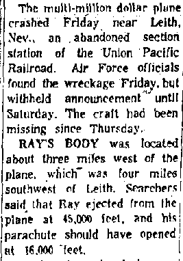
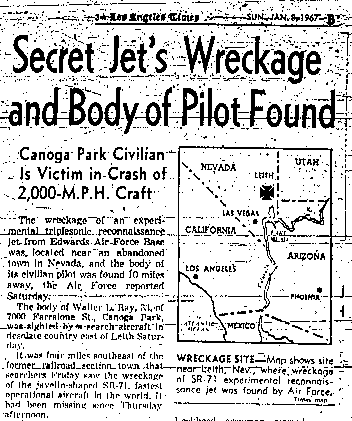
Next, I started doing the research and hit pay dirt immediately. In the Sunday, January 8, 1967 edition of the Los Angeles Times newspaper, I found a major article on the crash. The Air Force had decided to use the cover story of the crash being that of an SR-71, the unclassified sibling of the A-12. In a burst of amazing luck, the newspaper story precisely located the crash site, even showing a map! It said that the plane went down approximately four miles southeast of a place called Leith. It turned out Leith was merely a railroad siding on the Union Pacific railroad line running between Las Vegas and Salt Lake City. Leith was about 74 miles due east of the Groom Lake base, so a location about four miles southeast would be around 76 miles from Groom. This matched reasonably well with the official CIA history. This was going to be too easy! Maps of the area were secured, and I made plans to meet out there with Pete and we'd find this thing.
For a while prior to this, I had been poking into the field of remote viewing, which hadn't yet quite burst into the public's perception (I admit to having weird, ...uh I mean eclectic interests!). I had contact with a couple of remote viewers and thought this might be a useful test of this rather strange skill. The data back seemed to indicate a spot not southeast of Leith, but southwest. The terrain was described as flat, with the plane impacting at a flat angle, then wildly cartwheeling, and an engine tearing off and landing in a nearby ravine. Nothing more precise than that, however, but perhaps it would prove useful. Anyway, it painted an interesting picture.
On January 6, 1995 (the day after the 28th anniversary of the crash) Pete, Jeri and myself met at a spot a few miles southeast of Leith. The terrain was pretty benign, consisting of mild hills and ravines, your typical Nevada desert. I had laid out the search area on my topo maps and we set out just as a storm was brewing. It was, after all, January. Pete was quite a sight, wandering through the joshua trees and sage with his umbrella. Jeri and I just resigned ourselves to getting wet.
Perhaps a slight digression is in order to explain a few things about hunting for aircraft wrecks. There are three main rules to remember when it comes to hunts (goose chases is a better word) like these. I call them "Merlin's Laws" because that's where I got them, so complain to him, not me.
Merlin's laws are:
|
So what we were mainly looking for were traces of older roads that didn't seem to go to mining claims or other logical destinations. Or actually anything else that didn't seem like it belonged in the desert. We spent the morning climbing up and down the hills, covering a couple of square miles, looking for old roadways or other scars. We found a few, but it turned out they were very old and seemed to have been for old surveys of the area. Through breaks in the clouds I had caught glimpses of the area to the west, and it looked like what was described by the remote viewer, which got me to twitching. I couldn't quite bring myself to share the "remote viewing" info with Pete out of fear he'd think I was terminally strange. Hah! Toward the latter stages of the search, we would have started tossing chicken bones if we thought that would have helped! Pete suggested (only part jokingly!) contacting the departed spirit of Walt Ray with a Ouija Board. Things got that dismal, but that's getting ahead of the story.
I had sort of hoped to round a bend and find a couple of large, black titanium tails sticking out of a hillside. Alas, that was not to be. The weather was slowly deteriorating and it was starting to rain harder. Since the nearest pavement was perhaps 30 miles away, we thought it best to beat a hasty retreat. That turned out to be a wise thing, because as we were heading west on Kane Springs Road towards Highway 93, the rain had turned to a substantial amount of snow. We spent a number of anxious miles fish-tailing through the snow until we hit the luscious, safe pavement of Highway 93.
|
While passing back through Las Vegas, a thought occurred to me and we detoured to a local library. There we looked up issues of the Las Vegas Review-Journal and Sun for January 8, 1967. These newspapers told a slightly different story then the seemingly trustworthy Los Angeles Times. The Las Vegas newspapers said that the crash occurred 4 miles southwest of Leith, not southeast. There were also a lot of additional details about the crash and subsequent search, not included in the Times article. This led me to believe that perhaps the Las Vegas newspapers might be more accurate, and seemed to fit in with the remote viewing "data". Further, it was very close to the magic "70 miles from Groom" mark. So, obviously, we may have simply been looking in the wrong spot...the shape of things to come. We didn't have the street address, but it looked like at least we were in the right neighborhood.
So the info we had to that point suggested that 928 went down somewhere around 70 miles due east of Groom. A question I had was which way was it headed? I thought there only two possibilities, the first that the thing was making a beeline straight to Groom. The other scenario was that it was in the process of making a downwind leg for a northbound landing at Groom. The first scenario would have had the plane heading west, and with the second the plane would have been heading generally south or perhaps southwest.
Itching to get back our there on the basis on this new info, I returned on a solo trip about a week later. I spent most of a day scouring the area southeast of Leith in order to write off the area, as I foolishly believed the LA Times is usually accurate. . I covered a few more square miles and the only thing I found were a couple of neat old weather radiosondes that had been launched from the Desert Rock airstrip at the NTS. Cool, but not titanium. I managed to get up on a few of the high spots in the area and visually inspected the surroundings with binoculars. Nothing to be seen, and I was comfortable in ruling out the area. Still, you never know...
Late in the day, I headed south along the railroad tracks and crossed them at Lyman Crossing (called "Green Gates" by the locals, because of the obviously green gates). From there a poor road runs northwest, eventually joining with Kane Springs Road. This would get me into the area southwest of Leith. Carefully watching my odometer, as I neared the primary search zone, I spotted two crappy tire tracks running off to the northeast, just the direction the crash site should have been. This was getting interesting! Crawling along this 4wd track, it looked exactly like what I'd come to expect heading to a crash site. Then, after about a 1/2 mile, it ended in a large turnaround at the edge of a ravine. I shot out of the truck and peered over the edge.
I saw a large burnt spot on the far side of the ravine, but nothing else. I then realized this road had probably been blazed in by the BLM to quench a lightning-started fire. Crap! The sun was setting, so I returned to the truck and set up camp. After that was done, I thought I'd return in the twilight to see if I could find the precise spot the lightning struck. Might as well see if I could dig up a fulgarite as a consolation prize.
As I went over the edge into the ravine, I stopped suddenly. There, all around me, were shards of metal! I had been standing right above a crash site and had not seen it because it was on the slope beneath me. With flashlight in teeth, I scrambled around picking up pieces, pieces that had that magical, smokey-bronze look of titanium. It was too dark to really examine them, so I charged back to the truck to have a close look in the light. My high hopes quickly plummeted as I closely looked at the parts I had. Some pieces had dates of manufacture as recent as 1989 or 1990. Obviously not 928. But what was it?
Checking the site out in daylight showed whatever it was had impacted very hard, making a crater in the side of the ravine. The site had been reasonably picked up, with nothing really larger than palm sized, but there was still a lot of stuff scattered over 200 yards. It also looked pretty recent, no more than a couple of years old. Later, on visits to this site with others, it was determined the plane was probably an F-15. I also heard a story that after the Air Force did their cleanup, the BLM checked it out and said "Not so fast, boys", and made them clean up even more. It's an interesting site to visit, but you definitely need 4wd to get in the last 1/2 mile. It's about 3 miles SW of Leith.
I had noted a few other poor, jeep roads in the area, but had only limited time to explore the somewhat large area west of the railroad, so Jeri and I returned at the end of February to have another look. Somehow, we managed to talk Glenn Campbell into joining us (he obviously succumbed to our enthusiasm..."We'll probably find it this time, don't you want to be there?"), and met up with Agent X driving his trademark LeBaron convertible. We re-explored the F-15 site, as well as the surrounding area. Not a trace of an A-12 to be found. Glenn and X did a preposterous cross country drive looking for old road traces, but accomplished little other than having fun and looking like a Toyota commercial. We had covered the area southwest of Leith pretty well, and turned up nothing, so we headed home, empty handed again. This was getting to be a bad habit.
Later, I heard from Agent X that as he was leaving, driving north along the railroad, he came across an old cowboy tending some cattle near the Leith siding. As only Agent X can, he approached the gentleman, in full desert cammo, and asked if he knew anything about an old plane crash. Nonplussed by the cammo-clad apparition in front of him, the cowboy responded that there was one indeed, many years ago, and that they had surrounded the site with a couple hundred troops and two tanks. That sure sounded like it could be the A-12 site! But he told X that it was quite a few miles south, "...in the Mormons" (the Mormon Mountains), 15 or more miles south of where we were looking.
The Mormons are a pretty rugged range, with few access points. This was both good and bad. The ruggedness makes searching tough, but since there should be a road to the site, the limited access points narrow the search. After acquiring even more maps, Jeri and I returned in mid-February and drove along the railroad from Leith, south to Carp, and all the way south to Glendale, at I-15. Along the way, we poked into some very rugged canyons on the west slopes of the range, but found nothing but mining prospects. Still, there were other roads left to explore, but more trips would be needed for that. Overall, to that point it had been a fun and relaxing quest.
But my complacency was about to come to a crashing end....