LOW LEVELS
10.1. LOW LEVEL MILITARY TRAINING ROUTES.
10.1.1. AFFTC is the originating/scheduling agency for several IFR
Military Training Route (IR) and VFR (VR)
military training routes. These routes must be scheduled under AFFTCR
55-15. Aircraft using published VR
routes are required to squawk code 4000 unless otherwise assigned by
ATC. Complete route descriptions are in
Part AP/1B of FLIP.
10.1.2. AFFTC IR Routes:
10.1.2.1. IR 234. Cruise missile route from Desert MOA to Utah Test
and Training Range (UTTR).
10.1.2.2. IR 235. Reversal of IR 234.
10.1.2.3. IR 236. Contained entirely in restricted airspace and R-2508
MOAs. Use only for missions when route is
IMC. During VMC, use Green Route.
10.1.2.4. IR 237. Cruise missile route from Desert MOA near Tonopah
and return to Desert MOA.
10.1.2.5. IR 238. Reversal of IR 237.
10.1.2.6. IR 425. Reversal of IR 200 from UTTR to W 289.
10.1.3. AFFTC VR Routes:
10.1.3.1. VR 1205. Low level route from near Coaldale VORTAC through
Panamint Valley, R-2524 into R-2515.
10.1.3.2. VR 1206. Low level route from near Gorman through the Alpha
Corridor to the PIRA.
10.1.3.3. VR 1214. Low level route from Lucerne Valley, past Beatty
VORTAC to R-4807. (this is the Nellis Range Complex)
10.1.3.4. VR 1215. Low level route from Lucerne Valley, circling east
and north of R-2502 into R-2524.
10.1.3.5. VR 12l7. Low level route from Silverwood Lake, past Hector
VORTAC through the Barstow MOA into
R-2515.
10.1.3.6. VR 1218. Low level route from Silverwood Lake, north of R-2501
and return to R-2515 through Barstow
MOA.
10.1.3.7. VR 1293. Low level route from near Gorman to Isabella MOA.
10.1.4. Scheduling agencies for other low level routes within the R-2508
Complex.
10.1.4.1. MCAS El Toro - IR 211, IR 212.
*10.1.4.2. NAS LeMoore - VR 1255, VR 1262.
10.1.4.3. Point Mugu - IR 200.
*10.1.4.4. 146AW, Point Hueneme ľ Slow Speed Low Altitude Military
Training Route (SR) 390
10.1.5. Submit additional routes required for test purposes to 412
OG/CC for approval as part of the Test Safety
Plan. Justification must include reason existing routes are not adequate.
10.1.6. Submit changes to these routes or procedures to 412 OSS/OSAA.
412 TW/CC retains final approval
authority.
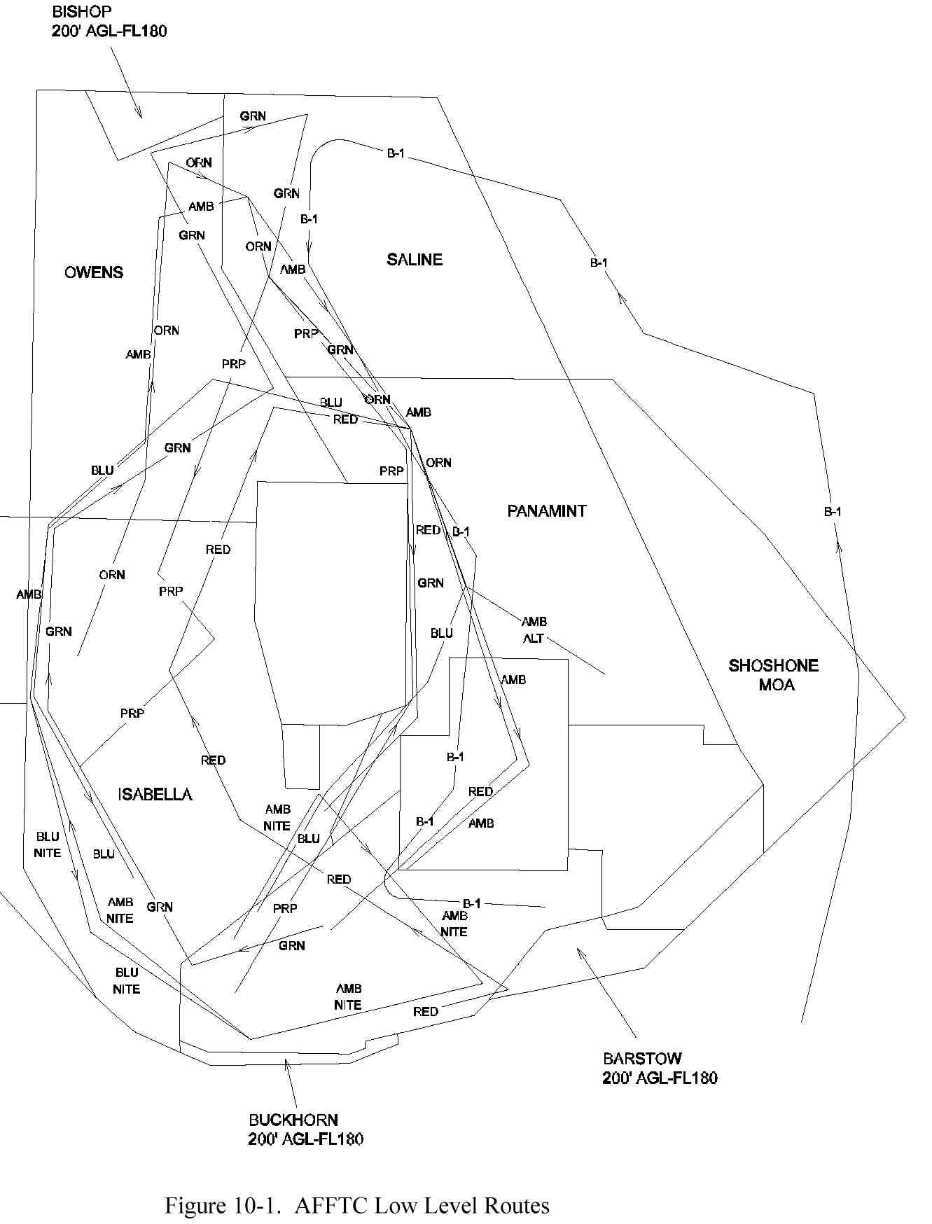
10.2. LOW LEVEL OPERATIONS IN R-2508 COMPLEX (Fig 10-1),
10.2.1. Use the following routes for test missions test mission preparation,
and proficiency training. Except for the
B-1 Low Level (LL) route (VR1205/VR1214) which uses portions of published
VR routes, all routes remain in the
R-2508 Complex. The routes adhere to ground rules established by 412
TW/CC.
10.2.3. The routes and backgrounds are: FOR BELOW MAP
10.2.3.1. RED ROUTE - Original LANTIRN #1 Route.
10.2.3.2. BLUE ROUTE - Original LANTIRN VIP #2 Route.
10.2.3.3. BLACK ROUTE - Alternate extension for Red or Blue routes.
10.2.3.4. GREEN ROUTE - Route designed to be a continuation of Red
route, or can be flown alone.
10.2.3.5. PURPLE ROUTE - Original F-16 #1.
10.2.3.6. AMBER ROUTE - Original LANTIRN #4.
10.2.3.7. BROWN ROUTE - Original AFTI F-16 VIP Route.
10.2.3.8. B1 LL - Uses parts of VR-1214 and VR-1205.
10.2.3.9. ORANGE ROUTE - Restricted to TPS use only.
Below may look rather daunting when first looking
at it, but it is easy to read and understand, from a military minded person
anyway but anyone with map skills should be ok. It is actually extremely
useful information to us Researchers.....
10.7. AFFTC LOW LEVEL ROUTE DESCRIPTIONS
10.7.1. RED ROUTE (CW)
PT COORDINATES
NORTH LAT
/WEST LONG
ELEV MAG CRSE
DIST DESCRIPTION/SURVEY POINT
1 34°52.18/117°33.43
2820
0
Dry lake by Ask-15 site/#88
2 34°57.25/117°07.70
2925
062
21.8 Hill in Barstow Cx/#89
3 35°21.60/117°53.20
1920
288
45.0 Saltdale (abandoned bldgs on
NW Koehn Lake/#109
4 35°44.80/118°07.40
3175
315
25.3 Walker Pass, Grvl Pit/#90
5 36°25.80/117°49.42
3796
005
44.0 Rd X E. Owens Lake/#91
(Start Alternate (BLACK RT) at Pt 5 - Return to Pt 6)
6 36°24.12/117°24.50
1695
078
20.7 N. Panamint Lake hill/#38
7 35°38.50/117°04.45
2198
145
49.2 Convoy hill in R-2524/#46
8 35°07.52/117°36.34
3002
205
39.0 Hwy. 395/Block House/#21
(BLACK ROUTE ALTERNATE)
from Pt 5 to:
1 36°37.80/117°59.30
4200
320
14.0 W.Slope Inyo Mtn Rng/#105
2 37°03.38/118°13.58
3880
320
40.7 NW end Tinemaha Dam/#104
3 37°00.90/117°54.60
5780
085
15.0 Mtn cabin 1.5 mi E. of
Road/#103
4 36°28.99/117°35.80
5310
140
34.3 Water tank 2 mi S. of
Road (Wilson Rnch)/#44
to Pt 6 098 10.0
REMARKS: Pt 1 to 2 along Hwy. 58 close to R-2515 boundary; Pt 4 to
5 avoid Sacatar Meadows Airport 1500' AGL or
three (3) NM; Pt 6 to 7 to 8 requires scheduling R-2524
RED ROUTE CONFLICTS
Pt 3 to 5 Purple Route Pt 8 to 10
Pt 5 to 7 Blue Route Pt 4 to 6
RED ROUTE ALTERNATE (BLACK ROUTE) CONFLICTS
Pts 1 through 4 Purple Route Pt 6 to 7
Blue/Black Route Pts 1 thru 4
10.7.2. BLUE ROUTE Counter Clockwise (CCW)
PT COORDINATES
NORTH LAT
/WEST LONG
ELEV MAG CRSE DIST DESCRIPTION/SURVEY
POINT
1 35°09.92/117°51.29 2573
0.0
Cal City tank/#40
2 35°29.25/117°38.29 3225
015
22.0 RR Y Searles Sta./#25
3 35°44.61/117°19.50 1618
035
21.2 Searles Lk storage yd. Cntr large bldg/#64
4 36°02.04/117°16.14 1210
353
19.0 Radar site at Ballarat/#26
5 36°23.07/117°24.22 2030
328
21.0 N. Lake Hill, Panamint/#65
(
Start alternate (BLACK ROUTE) at Pt 5 - return to Pt 6)
PT COORDINATES NORTH
LAT/WEST LONG
ELEV MAG CRSE DIST DESCRIPTION/SURVEY
POINT
6 36°28.59/118°00.86 3650
264
29.0 Bartlett mine (abandoned)
Owens Lk/#67
7 36°18.83/118°12.39 9930
227
13.0 Templeton Mtn./#68
8 36°06.58/118°29.06 8245
215
18.6 Needles Lookout Twr/#69
9 35°42.34/118°33.52 6980
166
24.0 Microwave Twr, Hill West of Isabella/#70
(Start Night Only Alternate)
10 35°15.00/118°15.00 6698
141
32.3 Emerald Mtn
(BLACK ROUTE ALTERNATE)
from Pt 5 to:
1 36°28.99/117°36.56 5310
290
11.0 2 mi. S. of Road/#44
2 37°00.90/117°54.60 5780
320
34.3 Cabin 1.5 mi. E. of Rd/#103
3 37°03.38/118°13.58 3880
265
15.0 NW end Tinemaha Dam/#104
4 36°37.80/117°59.30 4200
140
40.7 W.Slope Inyo Mtn Rng/#105
To Pt 6 175 12.0
(NIGHT ONLY ALTERNATE)
From Pt 9 to
11 35°02.20/118°18.70 3550
151 41.0 Mojave Cement
Plant/#98
12 34°49.14/117°53.48 2295
107 25.0 Wtr Tnk at Sled
Trk/#35
REMARKS: Pt 2 to 3 avoid Trona and Trona Aprt by 1500' AGL or three
(3) NM. At Point 9 until 10 miles past Point 9
deviate West of course to avoid Isabella Dam and settlement.
BLUE ROUTE CONFLICTS BLUE ROUTE CONFLICTS
Pt 2 - 3 Green Rte Pt 11 - 12 Pt 7 - 8 Amber Rte Pt 7 to 8
Pt 3 - 4 Green Rte Pt 10 - 11 Pt 8 - 9 Amber Rte Pt 7 to 8,
Pt 4 - 5 Green Rte Pt 10 - 11, Green Rte Pt 3 to 4
Red Rte Pt 6 - 7,
Amber Rte Pt 11 - 12 Pt 9 - 10 Amber Rte Pt 5 to 6,
Pt 5 - 6 Red Rte Pt 5 - 6 Green Rte Pt 2 to 3
BLUE Rte ALTERNATE (BLACK Rte) CONFLICTS
Pts 1 - 4 Amber Rte Pt 10 - 11, Green Rte Pts 5 - 9
Red/Black Alternate Pt. 1 thru 4
GREEN ROUTE (CW)
PT COORDINATES
NORTH LAT/WEST LONG ELEV MAG CRSE DIST DESCRIPTION/SURVEY
POINT
1 35°07.52/117°36.34 3002
0
Blockhouse/#21
2 35°01.29/118°01.30 2400
240 21.1 Relay Station/#56
3 35°38.78/118-28.82 2605
315 43.8 Cntr of W Dam/#7
4 36°07.60/118°27.30 5500
348 29.2 E. bend in river
5 36°28.10/117°49.30 3800
045 35.8 Rd X
6 37°03.02/118°12.50 3800
318 41.0 SE tip of dam/See
#104
7 37°05.60/117°57.30 6000
067 12.5 E. Rd bend
8 37°07.30/117°43.40 2800
063 11.5 W. tip dry lake
9 36°41.80/117°48.70 1300
173 35.7 Bldg S. of Salt
Lk/See #96
10 36°24.12/117°24.50 1695
096 21.0 N. lake hill/#38
11 35°39.20/117°21.50 1800
16 45.3 SW tip Searles
Lk/See #55
12 35°25.30/117°40.30 2800
213 20.5 Rd/RR crossing/See #16
REMARKS:
· Pt 1 is end point of RED ROUTE
· Pt 2 to 3 avoid Mojave airport by 5NM or 5,300ĺ MSL, and Cal
City and Kelso Valley airports by 1500' AGL
or three (3) NM. Btn 10 miles prior to, and three (3) miles past Point
3, deviate West of course to avoid
Isabella Dam and settlement.
· Pt 3 to 4 avoid Isabella Aprt by 1500' AGL or three (3) NM
· Pt 10 to 11 avoid Trona and Trona Aprt by 1500' AGL or three
(3) NM
GREEN ROUTE CONFLICTS
Pt 1 to 2 Purple Route Pt 1 to 2
Pt 2 to 5 Blue Route Pt 5 to 10
Purple Route Pt 7 to 8
Pt 5 to 9 Blue/Black Route (Alternate)
Pt 9 to 12 Blue Route Pt 1 to 6
Purple Route Pt 3 to 7
10.7.4. PURPLE ROUTE (CCW)
PT COORDINATES
NORTH LAT
/WEST LONG
ELEV MAG CRSE
DIST DESCRIPTION/SURVEY POINT
1 34°55.80/117°53.20
2296
0.0
F-16 Ramp
2 34°54.80/117°52.10
2309
0.0
Rwy 22 TD Point
3 35°12.70/117°45.20
3310
020
26.0 Hill TOS Hack
4 35°41.80/117°22.80
1850
018
34.9 RR bend/See #55
5 36°03.20/117°22.80
2600
345
21.0 Mine O'fly Fix
6 36°20.38/117°25.34
1576
337
110.3 Rd X CCRP Wpn Del/#45
Offset Aim Pt (OAP) Rng 18573 Brg 018.4 Elev 2030
7 36°41.77/117°49.48
1060
303
29.2 SW tip Salt Lake/#96
Alt Cal
8 36°01.20/118°14.70
9383
192
46.0 Firewatch Tower
9 35°52.00/118°00.00
7000
114
16.4 Mt. Peak/road
10 35°28.60/118°21.70 6800
206
27.0 Firewatch tower
REMARKS:
Pt 4 to 5 avoid Trona and Trona Airport by 1500' AGL or three (3) mi.
Pt 8 to 9 avoid Domeland and Sacatar Mdws airport.
PURPLE ROUTE CONFLICTS
Pt 2 to 3 Green Route Pt 1 to 2
Pt 3 to 4 Green Route Pt 11 to 12
Pt 4 to 5 Green Route Pt 10 to 11
Pt 5 to 6 Red Route Pt 6 to 7
Green Route Pt 10 to 11
Amber Route Pt 11 to 12
Pt 6 to 7 Amber Route Pt 10 to 11
Green Route Pt 9 to 10
Pt 8 to 9 Green Route Pt 4 to 5
10.7.5. AMBER ROUTE (CW)
PT COORDINATES
NORTH LAT
/WEST LONG
ELEV MAG CRSE
DIST DESCRIPTION/SURVEY POINT
1 35°05.13/117°56.29 2849
0.0
Pk of Desert Butte/#73
2 35°28.79/117°40.94 4470
010
29.0 Laurel Mt. Radar/#23
3 34°59.06/117°14.20 2563
127
310.2 Mtn Peak/#74
4 34°49.14/117°53.48 2295
237
33.0 Wtr Tnk at Sled Trk/#35
5 35°06.62/118°19.56 3930
293
28.4 Thpi Fwy/RR ovrpass/#31
6 35°42.34/118°33.52 6980
328
37.8 Tower W Isabella/#70
7 36°06.60/118°29.06 8245
354
24.8 Twr W. side/Needles/#69
8 36°18.83/118°12.39 9930
032
18.2 Templeton Mtn/#68
9 36°44.20/118°08.62 3821
352
24.9 Manzanar abandoned Rwy X/#28
OAP1 Rng 3700 Brg 198.0 Elev 3855 Building
10 36°51.55/117°52.69 2315
044
15.3 Danny's Mound/#27
11 36°24.12/117°24.50 1695
125
36.1 N. lake hill/#38 (See #65)
12 36°02.04/117°16.14 1210
148
23.5 Rdr W./Ballarat Lk/#26
13 35°34.63/117°01.87 2115
142
30.0 Stor site E. end Aprt/#76
14 35°16.74/117°23.89 2845
210
25.5 Bldgs S. Ctr of Cuddyback
Aprt/#20
From Pt 12 (ALTERNATE)
13A 35°46.05/116°49.98 2335 112 25.5 Lost Lake/#54
OAP2 Rng 31600 Brg 140.0 Elev 2200
VIP Rng 45600 Brg 109.0 Elev 1696
REMARKS: Pts 1 through 5 are for night flights only. For day flight,
proceed direct to Pt 5. Cross Pt 5 at 15,000ĺ MSL or
higher to descend and enter the route approximately five (5) nm north
of Pt 5. Pt 3 to 4 requires PIRA and Alpha Corridor. Pt
5 to 6 avoid Flying B Aprt by 1500' AGL or three (3) mi. Btn 10 and
six (6) miles prior to Pt 6, deviate West of course to
avoid Isabella Dam and settlement. Pt 8 to 9 climb to 3000' AGL (15,000
MSL), 16 miles prior to Pt 9 (nine (9) miles after Pt
8), to overfly Sequoia/ John Muir. Descend 11 miles prior to Pt 9 (14
miles after Pt 8). Pt 10 to 11 crosses Saline Valley
Saddle, use caution for other aircraft. Pt 12 to 13 requires R-2524.
Take alternate to Pt 13A or end route at Pt 12 if R-2524
not available. Pt 13 to 14 requires R-2524
AMBER ROUTE CONFLICTS
Pt 5 to 6 Blue Route Pt 9 to 10 Pt 10 to 11 Purple Route Pt 6 to 7
Pt 6 to 7 Blue Route Pt 8 to 9 Blue/Black Rte Alternate
Pt 7 to 8 Blue Route Pt 7 to 8 Pt 11 to 12 Blue Route Pt 4 to 5
Purple Route Pt 5 to 6
Pt 12 to 13 Blue Route Pt 3 to 4
10-12
10.7.6. BROWN ROUTE.
PT COORDINATES
NORTH LAT
/WEST LONG
ELEV MAG CRSE
DIST DESCRIPTION/SURVEY POINT
1 35°01.29/118°01.30 2675
0.0
Hwy. 58 N. of RR bend/See #56
2 35°03.50/117°49.00 2365
058
10.0 Clay Mine Rd X
3 34°55.50/117°41.00 2900
127
10.2 Mars Rd 1 mi S. AFAL
4 34°55.50/117°28.00 2775
075
10.9 Bldgs Kramer Hills
5 35°03.00/117°20.00 2275
027
10.5 Harper Lk Rd/RR X
6 35°12.00/117°27.00 3225
314
11.0 Fremont Pk Road
7 35°19.50/117°51.00 1990
275
21.2 S. Shore Koehn Lk
8 35°25.50/117°31.00 4985
052
17.9 Dome Mt.
9 35°22.50/117°40.00 3500
230
8.6 Randsburg
10 35°06.87/117°52.62 3145
197
18.0 Castle Butte/#22
*REMARKS: Pt 3 to 4 requires PIRA. Avoid the Det 7 AFRL by 5,300ö MSL
unless precoordinated.
10.7.7. B1 LL (CCW).
PT COORDINATES
NORTH LAT
/WEST LONG ELEV
MAG CRSE DIST DESCRIPTION/SURVEY POINT
1 34°27.00/117°00.00
0.0 VR 1214 Pt A
2 34°32.00/116°55.00
023
6.8 VR 1214 Pt B
3 34°51.00/116°34.00
029
25.6 VR 1214 Pt C
4 35°22.00/116°09.00
020
310.4 VR 1214 Pt D
5 35°49.00/116°08.00
347
26.8 VR 1214 Pt E
6 36°08.00/116°11.00
338
19.0 VR 1214 Pt F
7 36°30.00/116°15.00
338
22.4 VR 1214 Pt G
8 36°38.00/116°38.00
278
20.0 Climb to cross Pt 9 at 3000' AGL or above
9 36°53.00/116°54.00
305
20.0 Enter R-2508 Saline Work Area
10 37°05.50/117°46.00 272
13 NM prior to Pt 10, Lt turn descending to int. VR 1205.
Established on VR 1205 13 NM prior to Pt 11
11 36°40.00/117°41.00
156
VR 1205 Pt B
12 36°15.00/117°21.00
132
30.0 VR 1205 Pt C
13 36°04.00/117°11.00
130
13.8 VR 1205 Pt D
14 35°30.00/117°15.0
170
34.0 R2524 Alternate
15 35°10.00/117°33.00
202
13NM prior to Pt 15, Lt turn
to 075 mag to establish on
Black Mountain TFR.
16 35°11.00/117°02.00
075
Established on Black Mt. TFR
13 NM prior to Pt 16.
10.7.8. ORANGE ROUTE (CW).
PT COORDINATES
NORTH LAT
/WEST LONG
ELEV MAG CRSE DIST DESCRIPTION/SURVEY
POINT
0 34°54.90/117°51.70 2282
Edwards Runway 22
1 35°04.00/118°09.50 2787
Mojave Airport
*2 35°38.80/118°28.20 2600
322
38.0 Isabella Dam
*3 36°12.30/118°11.70 9410
008
36.1 Monache Mountain
*4 37°03.30/118°13.30 4500
344
51.0 Dam Spillway
*5 36°53.20/117°51.20 2500
104
20.5 Dry lake
*6 36°42.00/117°49.20 1200
158
11.3 W. tip of lake
*7 36°20.40/117°25.20 1575
124
29.0 Crossroads
*8 36°02.00/117°14.70 1200
141
20.3 Road/Lake shore
*9 35°42.20/117°23.70 1650
186
21.1 Factory
*REMARKS: TPS has scheduling priority
Avoid Mojave airport by 5NM or 5,300ĺ MSL
10 miles prior to 10 miles past Pt 2 deviate west to avoid Isabella
Dam settlement and Kern Airport by
3NM and 1500ö AGL.
Between Pt 3 and Pt 4 deviate east to avoid Kings Canyon National Park
Between Pt 3 and Pt 4 deviate east to avoid Independence airport by
three (3) NM and 1500ĺ AGL
Pt 8 to Pt 9 avoid Trona and the Trona airport by three (3) NM and
1500ĺ AGL
Begin climbout from low level three (3) NM south of Trona.
ORANGE ROUTE CONFLICTS
Pt 2 to 3 Purple Rt Pt 7 to 8
Pt 4 Close to Green Rt Pt 6 and Black Rt Alternate Pt 2.
Pt 4 to 5 Green Rt Pt 5 to 6
Pt 6 Close to Green Rt Pt 9 and Purple Rt Pt 7
Pt 6 to 7 Purple Rt Pt 6 to 7 and Green Rt Pt 9 to 10
Pt 7 to 8 Purple Rt Pt 5 to 6
Pt 8 to 9 All routes that pass through the Trona Gap