 |
|
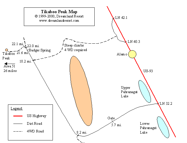
After the 1995 land grab, in which the closer Area 51 view spots "White Sides" and "Freedom Ridge" were seized by the Government, Tikaboo Peak, 26 miles from the Groom Lake Base, is now the closest view point. However, to get a glimpse of Area 51 you have to do some four-wheeling and serious hiking. And it takes a clear day to make out details with your binoculars or spotting scope. The best time is early in the morning, when you have the sun in the back, and there is not too much atmospheric heat distortion.
Before you start, please consider that it takes you into a very remote area, with virtually no traffic (and except for the top of Tikaboo no cell phone service). If your vehicle breaks down you are looking at a 22-mile hike back to US-93. Bring plenty of drinking water and food, as well as tools for minor repairs and at least one good spare tire. Also, you will be in almost 8000 ft. elevation, which means that even in summer the nights are cool. In spring and fall the nights can be very cold, even if it is hot in the valley. In winter, usually between November and March or early April, snow prevents any access to Tikaboo Peak.
It is not possible to drive all the way up to Tikaboo Peak. Even as a daring four-wheel driver you are looking at a one to three hour hike each way, depending on what shape you are in and how much gear you are carrying. That includes steep climbs, partially on loose shale, in 8000 ft. elevation, where the air is much thinner than at sea level. If you are in less than average shape you should seriously reconsider your plans.
There is no water on Tikaboo or anywhere on the way, and you need to take at least one gallon of drinking water per person and day. Try not to make the hike alone, and make sure to let someone know where you are going, and when you expect to be back.
Easiest access to Tikaboo Peak is from mile marker LN 32.2 on US-93. This unmarked turnoff to the west is easy to miss. Look for a stop sign about 0.4 miles north of the marked entrance to the Pahranagat Wildlife Refuge. There is another, shorter, access road further north, but it has some steep climbs and requires 4WD.
After you turn off at LN 32.2 you get on a maintained dirt road, which is passable for most sturdy cars. However, after rains the road may be washed out and require 4WD. In the above map all mile markers along the dirt road are driving distance to the intersection with US-93 by the stop sign. Always follow the main road to get to Badger Spring.
| 0.0 mi. | N 37°16.823' W115°07.159' |
Unmarked gate to the Pahranagat Wildlife Area at the intersection with US-93, approx. 0.35 miles north of the marked road to the ranger station. If you find the gate closed it is ok to open it to drive through, as long as you close it after you. If it is open leave it open. |
| 5.1 mi. | N 37°15.066' W115°11.789' |
Fork. Keep left, following the main road. |
| 5.7 mi. | N 37°14.542' W115°11.950' |
Fence and gate. Again, if the gate is closed it is ok to open it, drive through and close it. When closed, the gate looks like a solid fence, but it can be opened. If you can't figure out how to open it, you probably should not be out there in the first place. Be careful not to damage the gate, and be sure to close it properly behind you. |
| 8.2 mi. | N 37°12.425' W115°11.709' |
Fork. Follow the main road, which makes a sharp right turn here. |
| 18.2 mi. | N 37°18.907' W115°17.823' |
Road intersects from the right. That is the rugged shortcut mentioned earlier. Continue straight on the main road. From here on the road may require 4WD at certain times, or be completely impassable. |
| 21.6 mi. | N 37°20.760' W115°20.495' |
Badger Spring. Keep right here. From here on the road becomes more difficult, and is only passable for 4WD vehicles. You can camp here and hike the rest of the way. Only about 0.5 miles from here the road ends anyway. |
| 21.85 mi. | N 37°20.888' W115°20.625' |
A road intersects from the left. Keep right and stay on the main road. |
| 22.0 mi. | N 37°21.000' W115°20.687' |
The road forks here, keep left. The road continues steep uphill, and only experienced 4WD drivers with a high clearance vehicle should continue. |
| 22.1 mi. | N 37°20.974' W115°20.783' |
End of the passable road. There is a clearing with enough room to camp and park your vehicle, if you made it up here. From here on a very rugged dirt road and then a hiking trail, marked by rock cairns, leads up to Tikaboo Peak. Depending on your shape, and the amount of gear you are carrying, the hike will take between one and three hours. |
The first part of the hike leads up to a "false summit", first moderately steep and near the summit quite steep, on loose shale. This is the hardest part of the hike, especially if you are carrying a heavy pack.
About 50 yards below the summit the trail turns right, towards a rock outcropping. The trail is mostly level here. Follow it around the left side of the rocks, and then downhill on the other side.
You come to a saddle, that offers plenty of room to camp. The trail continues uphill on the other side, up to the real Tikaboo Peak. This part is moderately steep, and leads through bushes and trees. It is easy to loose the trail here, but if you keep going uphill you will eventually get to the peak.
There is a small rocky platform on top, from where you can see the base, behind the Jumbled Hills and Freedom Ridge. Right below the peak is plenty of camping space in between the trees.
The mile markers in the table below are hiking distance to the parking area.
| 0.0 mi. | N 37°20.974' W115°20.783' |
Parking area. Only accessible for 4WD high-clearance vehicles. |
| 0.2 mi. | N 37°20.827' W115°20.842' |
End of the rugged dirt road, and start of the hiking trail. Do not attempt to drive up to here, unless you are a very experienced 4WD driver with a familiar high clearence vehicle in excellent shape. There is a good chance that you will cause serious damage to your vehicle (as two of my friends have) and/or get yourself hopelessly stuck. |
| 0.45 mi. | N 37°20.667' W115°21.044' |
Just below "false summit". Turn right here. |
| 0.7 mi. | N 37°20.667' W115°21.301' |
Saddle. Good camp site. |
| 1.0 mi. | N 37°20.654' W115°21.543' |
Tikaboo Peak. |
On recent hikes we noticed a significant increase in litter along the trail. Sure, the pack gets heavier by the minute, but PLEASE pick up all litter behind you, including bottle caps, notes and other small items. Do not bury it. The next Tikaboo hiker will appreciate it. Thank you!