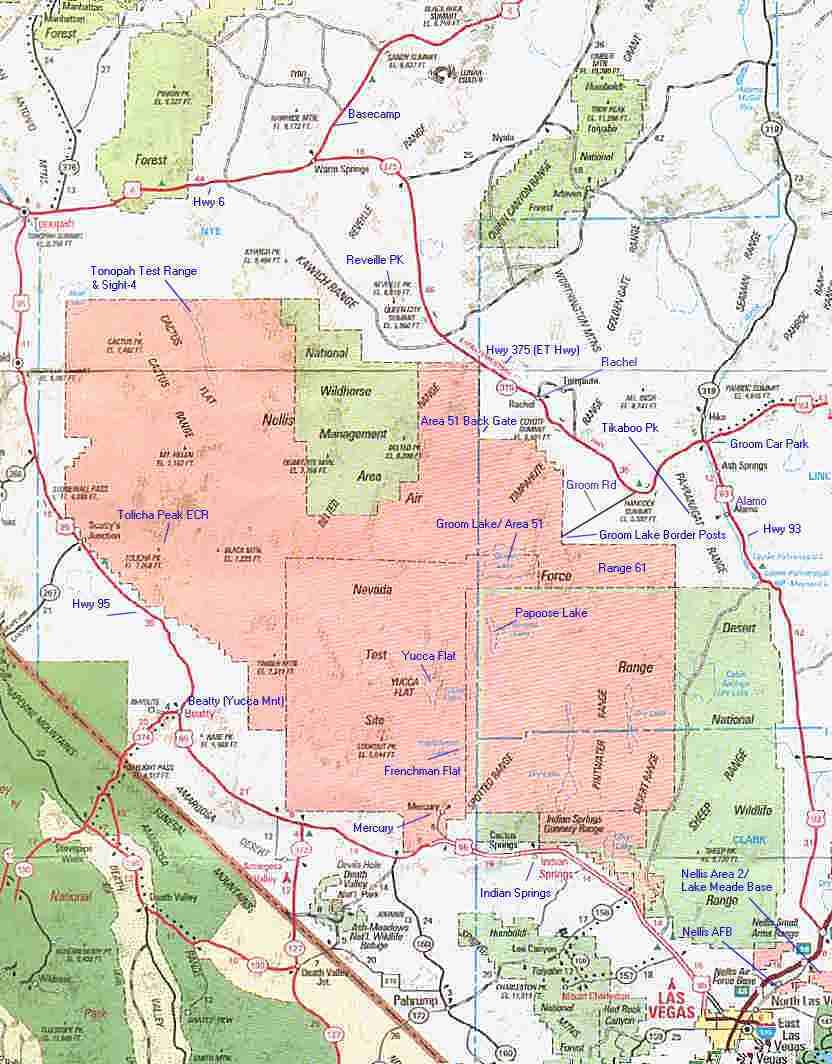
image source: British AA Road Map. Edited by Richard Cliff Copyright 1999. All Rights Reserved
Below is an article detailing on WHAT you might see while out driving
through southern Nevada, in the way of aircraft and facilities. Worth a
look if you havent got a clue in that field!
Article is written by Richard Cliff ©1999. All Rights Reserved.
image source: British AA Road Map. Edited by Richard Cliff Copyright
1999. All Rights Reserved
Starting from the bottom of the map and going counter clockwise are descriptions below of sites, what you will see, and things 'on the way' to each site.
Nellis AFB -
Located North East of Las Vegas. Home of the Air Warfare Center and Tactical
Weapons School. Nellis also serves as the deployment and operations base
for Red Flag and Air Warrior Exercises, and the Firepower Demo Capstone on Range 63
near Indian springs. Nellis owns most of the Nevada Bombing Ranges.
Frequently seen at Nellis AFB are the following aircraft:
| A-10A & OA-10A THUNDERBOLT II (TANKBUSTER) | C-130 / MC-130 HERCULES & COMBAT TALON/SHADOW |
| F-15 C/D EAGLE | B-1B LANCER |
| F-15 E 'STRIKE' EAGLE | B-52H STRATOFORTRESS |
| F-16 FIGHTING FALCON(VIPER) MANY VARIANTS | B-2A SPIRIT |
| KC-135R STRATOTANKER / KC-10 EXTENDER TANKERS | F-117 NIGHTHAWK |
Many foreign nations are usually seen here during Red Flag exercises. Aircraft usually seen flying sorties from Nellis are:
| United Kingdom | Germany | Canada |
| RAF Tornado GR-1/GR-4 RAF Jaguars GR-1/GR-3 RAF Harrier GR-7s C-130 Hercules, VC10, TriStar Tankers |
GAF F-4E/F Phantom GAF C-160 Transall GAF C-130 Hercules GAF Mig-29 Fulcrums |
CAF F/A-18(CF-188) CC-130 Hercules |
Nellis Area 2 / Lake Mead Base
- Located a mile or so east of Nellis AFB itself is Lake Mead Base.
Located inside this area is one, if not the largest, USAF Nuclear
weapons Arsenal. Something Las Vegas residents sometimes worry about!
The weapons are stored in vast underground bunkers. Also situated on
the base and in the perimiter is a low security Prison.
Indian Springs -
Located on Highway 95 and approximately 40 road miles from Las vegas. Indian
Springs is home to a USAF Auxillery Airbase.
Indian Springs Aux AB operates the Predator UAV. The famed Thunderbirds
Display team in their F-16's train here everyday when not doing airshows
so drivers are given a free air display each day. The base serves as a
Relief Landing Ground for Nellis incase of an Emergency. Indian Springs
has Range 63 behind it, which also extends along Highway 95 for a few miles.
From the highway you can spot many Real but old Tanks. APCs, mock vehicles
and other targets. These ranges are very active and if your lucky you are
treated to a spectacular 'fireworks' display as Nellis based aircraft literally
'rip' the hell out this range. Capstone Firepower Demo is also hosted here.
On the other side of the highway to the range, is another low security
Prison. On a week day sitting here watching a free airshow and aircraft
blasting the ranges, plus Predator can be very interesting, a restuarant
and toilet and petrol/gas facilities are here on the side of the highway
also.
Aircraft you will and may see in and around Indian springs on the Ranges
frequently are:
| Predator UAV | F-16 Falcon (Thunderbirds) |
| F-16 Falcon | F-15C/D and E Eagle |
| A/OA-10A Thunderbolt II | B-52H Stratofortress |
| B-1B Lancer | F-117 Nighthawk |
| B-2A Spirit | Various Foreign aircraft |
Mercury, Frenchman Flat and Yucca Flat
- Located further up the highway from Indian springs approximately
19 road miles. This little area is easy to spot, and when driving there
for the first time looks something out of the future, very strange place.
Located actually off the highway, from the road all you can see is
an area covered with buildings and mobile buildings. When the sun is shining
from the south, everything glitters in the sun, shining bright which makes
it look futuristic(sort of)
Its a funny place...you can't get into mercury without going through
Security Guarded Posts. What is in view is a very small air-strip with
a very modern control tower. (Desert Rock Airstrip)Thats it! no other building
on the air strip apart from the tower which makes it look odd! Looking
up past Mercury is the Nevada National Security Site (NNSS)
Sitting upon a ridge between Frenchman and Yucca flat is Control Point
1 (CP-1) which oversaw all nuclear test operations albeit above ground
on Frenchman or Below ground on Yucca. Mercury was a staging area for troops
who were used as Guinee Pigs inthe above ground testing on Frenchman. Many
video footage from the Dept of Energy(DoE) have shown troops with their
heads down in bunkers and trenches, with a Blast wave (shock wave) coming
over the trenches from the Air burst. After this had passed the troops
popped up with darkened goggles to see the absolutely amazing sight of
the mushroom cloud towering above them just miles away. Of course, Live
tests were carried out too, in the Ground zero and just 1 or so miles away
from Ground zero.
DoE put Pigs and Sheep on the flat, tied up to posts and then tested
an 'airburst' atomic bomb. The results were very upsetting for animal lovers.
Video footage showed the animals being completely torn apart and burnt
to cinders instantly. Another test here was how buildings stood up the
Blast Wave and heat.
Dummies of humans were placed inside houses built on the flat. The
Atomic bomb was then detonated and again caught on video cameras.
Immediately after the detonation, the blast Wave together with the
Heat Wave spread out an a terrifying speed ripping the buildings apart
and blowing down trees, burning everything that could be burned in thousands
of degrees heat. After the innitial wave had blasted outwards, the resulting
mushroom cloud gathered its pace and towered above the flat in a huge fireball.
The fireball, being so big sucked Back all the air around the blast for
miles creating a vacuum which resulted in the buildings that did survive
being sucked back into the rising fireball and mushroom cloud. Anything
that did survive the innitial blast wave going outwards is now blasted
backwards and sucked into the fire. From miles around the air is sucked
in, anyone caught in this would be either burnt alive, torn to peices or
have there lungs sucked out of their mouths, or worst still, the whole
body being sucked into the fireball. Of course, if you still don't die
and live within hundreds of miles of the blast, Radiation(Nuclear) fallout
will eventually kill you and deform your unborn children. Similar effects
were studied when testing the most powerful bomb ever second only to the
nuclear bomb, the Fuel Air Bomb. Now you know what the innocent civilians
went through in Nagasaki and Hiroshima.
Aircraft you may see around Mercury are:
| A-10A / OA-10A Thunderbolt II | B-1B Lancer |
| F-16 Falcon | B-2A Spirit |
| F-15 Eagle and Strike Eagle | F-117 Nighthawk |
| B-52H StratoFortress | C-130 Hercules / MC-130 Combat Talon / Shadow |
Beatty
- Located again on Hwy 95 and approximately 52 road miles North west
of Mercury.
Beatty is another weird looking town. shadowed by a large mountain
and various ridges above the town, this is home to the Department of Atomic
Energy Commissions 'Yucca mountain Facility and Museum'. Controversy
nowsurrounds this very small facility. Plans are made to dump atomic waste
in the area at Yucca Mnt. People living in the town realise the harmful
effects given by this, seeing also evidence of the same waste being stored
at Groom lake, slowly killing the workers who work at Groom. People as
far away as Lone Pine in California are protesting about this plan as they
too feel they are in danger as winds would bear down on them carrying the
waste in the air.
Beatty also used to stage troops for the tests and , as with Mercury,
NTS workers stage and live here.
Driving from Beatty to Mercury you can get to see some good facilties.
When driving at night or daytime and when not too much haze is in the air,
look to the east (left) of the highway. All the way down to Mercury you
will see various large and small complexes dotted around the NTS.
I recently spotted a very large train, with cargo carriers white in
colour. A Large tunnel complex appeared to be in front of the train. Behind
the train was large facilities with high water towers, masts, comms annexes,
buildings built into the side of mountains, all sorts. You'll need binoculars
to see these. And it can be very interesting to see what is going on.
The Yucca Mnt facility in Beatty is situated as follows:
Driving up from Mercury on highway 95, when in Beatty turn Left onto
Hwy 374 towards Death Valley. As you turn left onto 374, a few yards up
the road on your right is the facility. Its not very big but not hard to
miss either. the Facility is a research facility and apparently there is
also an aircraft esearch facility here also but i never saw it, only the
Yucca Mnt complex. Petrol/gas and eateries/washrooms are located here.
Tolicha Peak -
Located
in the Nellis Gunnery and Bombing Range to the East of Hwy 95 approximately
10-15 air miles inside the border.
This base was found by Tom Mahood, Glenn Campbell and their Pilot when
they flew over R-4807.(now open to the public some sundays but still limited
and you have to seriously obey the ATC as Tom and Co. found out)
Tolicha Peak can apparently also be viewed by climbing GoldField Mountain.
Goldfield on the map above is located west of Cactus Flat and is obscured
by a line on the map approximately 35-40 air miles North West of Tolicha
Peak.
Tolicha Peak is an Electronic Combat Range(ECR) For people in the UK,
a similar range is the Spadeadam Range in Northumbria/Cumbria
Located here is an airfield(photo on Tom's Page) called the 'Korean'
Airfield.
Here's a Sat image : source USGS
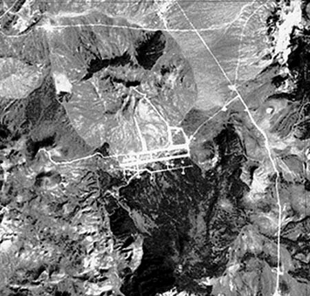
This airfield is used for Green Flag Exercises for ECR training.
Located on the airfield are many mothballed(out of service) aircraft
used as targets. On the range also are Russian made AAA(Anti Aircraft Artillery)
and SAM sites together with the Radar systems. The range is used to train
pilots in Jamming, evading radar, and evading threats made by the Ex-Warsaw
Pact Countries.
A Similar area is sight-4 located at Tonopah ECR. More on this Later.
If climbing up Goldfield Peak, you 'may' be rewarding some time with
a sight of a Black Project. Just like at Tonopah ECR , Stealth aircraft
new and old use this area to test the stealth against up to date soviet
made Radar systems.
Aircraft you may see at Tolicha from GoldField and surrounds are:
| F-117 Nighthawk | Various Black Project aircraft based at Groom , Tonopah & Edward's |
| B-2A Spirit | Various Nellis Based aircraft |
Tonopah Test Range -
Located approximately 35 road miles SW of the town of Tonopah.
Driving along Hwy 6 west you will actually come to a sign showing you
the way to this Semi-Secret Airbase. The sign you cannot miss! as it is
a Rocket pointing in the direction of TTR down a road for 35 miles or so.
Tonopah is explained with images on another part of the Website: Tonopah
For Sight-4 ECR please click the link above also.
Aircraft seen and may be seen at and around the area are:
| B-2A Spirit | B-1B Lancer |
| B-52H Stratofortress | A-10 Thunderbolt II |
| F-15 Eagle | F-16 Falcon |
| F-117 Nighthawk | Various Black Projects from Groom / Area 51 aswell as Tonopah also. |
| Edwards AFB aircraft | Based 'spooky' things! |
Basecamp
- Located on Highway 6 still. From Highway 375(ET) or Highway 6 keep
going until you come to the small town of Warm Springs. approximately 44
road miles east of Tonopah town and approximately 62 road miles North of
Rachel on Highway 375(ET). From Warm Springs drive north west on Hwy 6.
Shortly you will come across an airfield stuck right next to the road,
and next to road, is literally NEXT to the road!!!
This is Basecamp. An Auxillery Airforce Base.
Immediate arrival and your reaction should be ' ermm is this
it?' well yeah, it is 'just it' . The airfield is very 'non - active'.
You can literally drive onto the runway but please don't. anyway, upon
your arrival alas you should spot a 4WD vehicle either watching you from
a distance inside the base, or better still driving right at you fast!.
This as Glenn Campbell named him, is the 'Troll' of basecamp. or as we
call it, Security. We cannot however call him a 'camo dude'! as he wears
normal clothes. he is also however 'getting on a bit' which probably fires
his anger!!
He seems very 'nice' towards you, hmm, ok then, seems very UNFRIENDLY!
towards you and unlike the Camo-dudes, this man approaches you Head to
head with some strict words if you approach the base too close, but then
you can't really help that!.
Apparent on base you will see(if the troll's head is out of the way)
several vehicles, which includes a snow tracked vehicle, with very wide
tracks for low ground force. Also theres quite a few buildings on base,
including a living area, canteen area, fire station and other buildings.
Now what you will find very interesting is two things first...1. this
'non'active airfield is owned by the AFFTC at Edwards AFB, the same people
who own Area 51 along with the DoE.(which used this airfield in the atomic
testing days).. 2. the Runway at this very seemingly inactive airforce
base was re-paved a few years ago. yeah re-paved for an inactive base!
Also, dotted down the sides of the runway are fire extinguishers. So, link
to link, it comes across as a sort of Emergency Diversional Airfield for
some other base, and may actually be a Satellite or RLG(Relief Landing
Ground) Base for Groom Lake/Area 51 and also for Tonopah Test Range.
The runway is over 6000ft long indicating that it can't be used for
large aircraft like the B52 or B1B. On the mountain in-line with the runway
you will see a communications annex. This is thought to be a radar also,
possibly for TTR/Groom and Nellis Exercises. Atop this mountain is microwave
towers, satellite dishes and the radar. Located also at the airfield is
a DME and VORTAC system. DME is Distance Measuring Equipment. and
VORTAC is Very High Frequency Omni-Directional Range TACtical Air Navigation.
DME and VOR are used a civil aircraft waypoint system which transmits
a given freq to the aircraft, the aircraft then picks up the freqs which
shows his bearing to the VOR. The DME shows the Bearing and Range from
the aircraft to the DME. The TAC is short for TACtical Air Navigation
which is used only by the Military for the same purpose as VORs. TACANS
are usually plotted on frequent routes, so military aircraft can stay on
the same route and just 'follow' the TACANS to its destination.
Nothing much else is at Basecamp. The base , aswell as being a diversional
airfield is a base for military personell for recreation. why i don't know,
would you spend your recreational times stuck in the middle of a desert?
Nellis Pilots frequently fly over basecamp but is out of bounds to
civil pilots. It is also shown as Out of bounds on the Nellis Air charts(the
one i can't find)
Further up highway 6 you will come to where the largest ever atomic
detonation occured in the United States. The name 'Project Faultless' was
given to this test.
You may be thinking like others are, YES this test was done on Public
Land! Basecamp back in the days of the Faultless Project was a staging
area used much like Mercury was. Today, the massive crater left behind
by the detonation can be viewed by standing a purposely built platform
overlooking the crater.
Further up from here and you will end up where NASA Astronauts were
trained for some of the Moon projects and to get used to what the moon
looked like.
This attraction is the 'Lunar Crater'.
Aircraft frequently seen or may be seen are:
| Red and Green Flag Exercise aircraft which includes the above and Foreign
aircraft such as RAF and German aircraft. All fly over and do not land
Tonopah Test Range Aircraft such as B-2A, B-1B and Black Budget Aircraft if you are lucky. |
Reveille Peak -
Okay, this mountain is new to the Black Project's spotters. Recently an
expedition was mounted up the peak by the Swiss Mountain Bat and his compatriots.
What they saw was an amazing sight...they ended up looking right down the
Groom Lake/Area 51 Runways, both of them!!
The Base from this Peak is approximately 45 miles south. Of course
as you imagine, the most powerful cameras are needed or a telescope also.
During there expedition, the Swiss bat and his Compatriots spotted
the latest Black Project being tested here. The Project, according the
Tower was called 'FastMover' and the Bat's Transcript can be found on the
Black-Triangle Homepage.
Aircraft seen here are the same as above, many Dogfights and 'run-ins' are made here to the Ranges especially during Red and Green Flag.
Rachel - Rachel is a tiny town with mobile homes. located here is the Little A'Le'Inn with restaurant, gift shop and motel. Living here also are workers and camo dudes. This is the only place for Gas/Petrol for miles so be careful.
Aircraft seen or maybe seen here are the same as above, Dogfights, general handling etc etc.
Back Gate to Area 51 -
The Back Gate to Area 51 is located 9 miles from Rachel. This Border post
is actually the secondary entrance to Groom on this side of the base. Being
secondary you think to yourself, well it must be extremely poorly marked
border line, even worse than the main Groom Lake road entrance. Hmmm...well
this entrance seems to be done 'properly'!! When you arrive at the border,
you KNOW you have arrived at the border!
Located here is a nice guard pad, which looks like a disney world kiosk.
Also the entrance has a border fence and a barrier going across the road.
Cameras are here, but also here is of course the guards, inside the
kiosk type building with blacked out windows.
The road is used often and recently been used to ferry contruction
vehicles into the base. (don't forget popular mechanics thinks this base
is closed)
Recently, during the contruction vehicles being moved in, the Author
and resident of Rachel of the 'Dreamland resort' took photos of the vehicles
and when doing do, was actually chased for several miles up the dirt track
by a camo dude! Read his story at the Dreamland resort site.
The same guard complex is actually on Groom Lake road, but instead
of being at the border, it is over 1/2 a mile inside the border and out
of sight.
Recent photos taken by a part-time resident of Rachel has shown Heavy
Contruction Vehicles being moved in by Flat-Bed trucks. For Some reason
Joerg(the resident) was chased off by a camo-dude in the white jeep on
public land..These Contruction Vehicles were either taken into Area 51(very
likely as it is slowly expanding) or they were taken to Quartzite Mnt Bombing
Range. However, we will never know where they went, they could be making
another Airfield for all we know! as they were extremely large Bul-Dozers
such as D-9's
Tikaboo Peak - Closest view spot to Area 51 on public land.
Groom Lake Road - Well, this is self explanitory
Groom Lake Car Park -
This area is at the intersection of Highway 93 and highway 375(ET).
Situated here is an old casino and is where workers of Groom Lake park
up and commute to Area 51 by Bus. Please do not 'lurk' around this area,
you will get stopped by the police and also the Camo dudes patrol this
area. Do not attempt to follow the bus, you can follow it down Groom road,
but don't forget to stop at the signs!!! Don't however go following the
bus around its regular stops, the sheriff will eventually catch up with
you.
The bus at night and on weekends parks at Alamo, opposite the County
Court.
Another tip is not to approach the workers for anything, you know very
well they cannot and will not give information to you. And if you were
after information on Black Projects, about 90% would'nt of even seen any
aircraft flying. Most of the serious flying of the Serious aircraft is
done on weekends when most of the workers are 'out of the way'. However
always keep looking around the sky, not always around Groom lake, as the
aircraft test to the east aswell.
Best times to view aircraft are early in the morning, when sun is rising,
you will see Janet aircraft going in and out. Test flying is also done
here possible BEFORE the janet flights even get there. Very eary in the
morning around 4-6am. Another testing time is when the sun is setting.
Most workers have gone home by 4pm so testing can be safely done from 5pm
onwards. Word of advice too, don't get too excited if you see glowing lights
around the base, or appear over the base, these are usually Flares dropped
out of Nellis based fighters BEHIND the base and on Range 61.
However, be on the look out for UAVs and the FASTMOVER(s).
Range 61 -
Range 61 is where the Popular Mechanic's reporter stood when he said 'Area 51
was closed down and moved to green river, utah'
Well we all know that is complete Bollocks(for the Brits) and complete
Crap(for the Americans and rest of world). Range 61 is a very active Nellis
Gunnery and bombing Range and extends down for a fair few miles southwards!
The Range is used extensively during Red Flag.