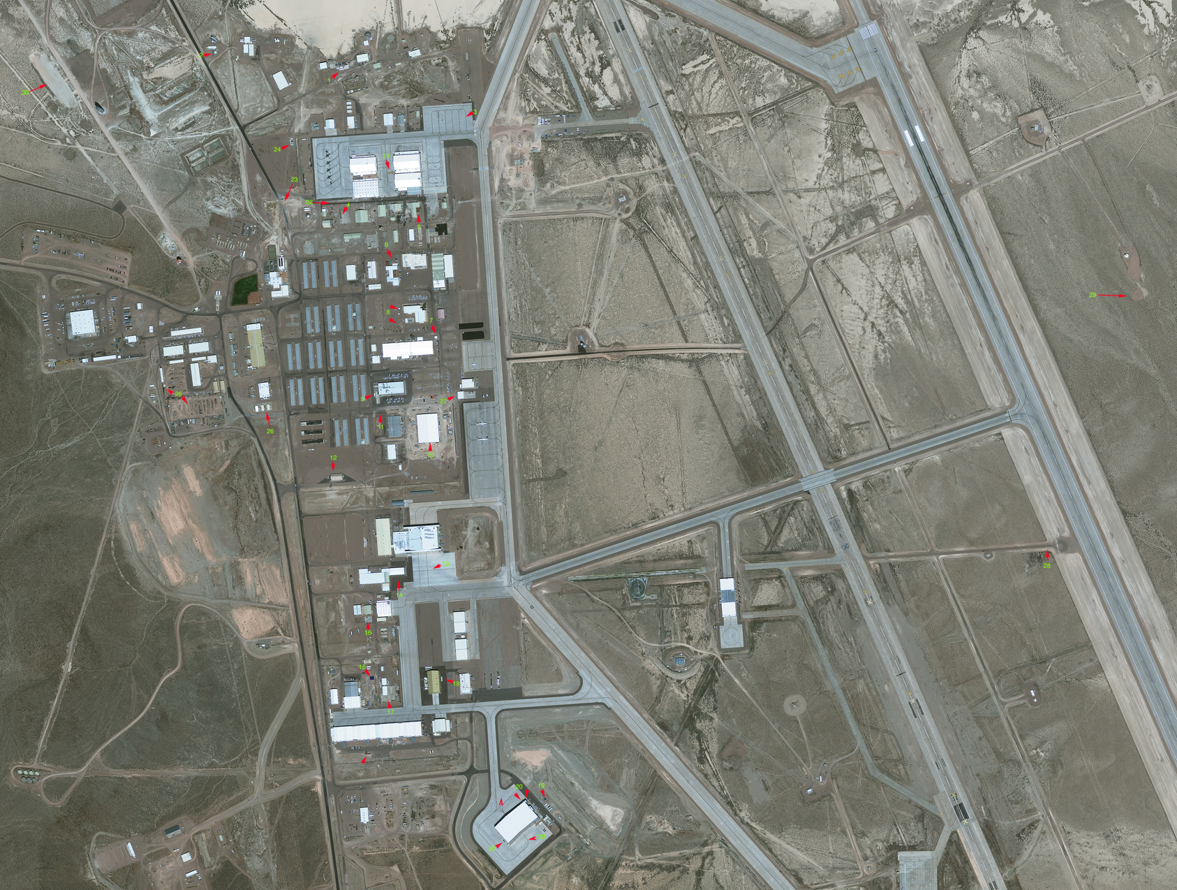
Hi Guys..I made a map (which I'll forward to you Joerg if you want to post it..) and of 30 differences I note between the 2010 Google Earth Image and our new Aug 23, 2011 image. I like playing the "can you spot the change?" game!
Several of these have been mentioned before, but many have not. I think it's most interesting how things are happening all over the base; not just in one area. Particularly interesting are the clearing of land by the large triangular tower and the odd cross shaped structure by the 'berm'.
I made a table that is hard to get to format correctly here on the forum...I'm going to do my best to make it legible.
Object Number Coordinates Description
1 37 14ĺ50.59 N
115 48ĺ53.79 New construction type materials on concrete pads between Range BE Office
2 37 14ĺ 51.72 N
115 49ĺ 12.24 Rail-like object, not a vehicle in the lot S of DYCOMS Dish control bld
3 37 14ĺ 45.50 N
115 48ĺ 44.49 Repainting with 5th loop ôaddedö
4 37 14ĺ 37.11 N
115 48ĺ 57.93
New objects laid out on a concrete pad N of Fire Station
5 37 14ĺ 37.76 N
115 48ĺ 49.77 Alteration of roof ľ repair? On old U2 hanger
6 37 14ĺ33.54 N
115 48ĺ 52.51 Minor upgrades to tent outside main base; restriping of parking lot
7 37 14ĺ26.62 N
115 48ĺ 48.16 Construction of small structure on NE corner of Test Engineering Bld. Early phase of construction seen in 2010 image
8 37 14ĺ29.11 N
115 48ĺ 52.16
2 new small structures and small changes to the materials seen just W of Consolidated Services
9 37 14ĺ21.76 N
115 48ĺ 54.81 New small structure on SW corner of New Base HQ
10 37 14ĺ19.06 N
115 48ĺ 48.55 Large new building between PMEL and Janet ramp ľ the most obvious new construction.
11 37 14ĺ20.21 N
115 48ĺ 53.81 Removed: girder-like object..maybe paving machine? Now only a stripe is seen ľ NW of PMEL
12 37 14ĺ14.64 N
115 48ĺ59.06 New Quonset hut added S of dorms ľ perhaps security or access control for new building?
13 37 14ĺ06.58 N
115 48ĺ 48.26 Large addition to tarmac/ramp S of Hanger 18 Two runway stripes painted leading from hanger
14 37 14ĺ05.92 N
115 48ĺ 52.62 ôloading dockö like stripes added to New Extension Bld
15 37 13ĺ 57.39 N
115 48ĺ 55.75 Solar panel blue color building/panels? Just NE of steam plant
16 37 14ĺ 02.20 N
115 48ĺ 55.96 Removed: 2 small structures on a pad S of hanger 8 support building
17 37 13ĺ 55.00 N
115 48ĺ 55.52 Removed: jet deflector just N of South ramp near ôNew Building west of Hanger 17ö
18 37 13ĺ 56.59 N
115 48ĺ 47.75 New white structure or shipping container E of large green hanger at the South Ramp
19 37 13ĺ 46.40 N
115 48ĺ 36.98 New small black cross shaped structure between New South hanger and the ôbermö
20 37 13ĺ 42.71 N
115 48ĺ 41.36 Minor changes around New South Hanger: changes to striping; oject at SW corner repainted from white to black; added a small overhang at NE corner & removed: aerial drones at NE corner
21 37 14ĺ 40.99 N
115 48ĺ 48.53 Brown discoloration on tarmac near Hanger 5 has expanded
22 37 14ĺ 38.34 N
115 48ĺ 58.56 Improvements to ramp/road between Hanger 7 and old U2 Hangers
23 37 14ĺ 38.95 N
115 49ĺ 04.08 Some type of construction/excavation going on near the road
24 37 14ĺ 43.75 N
115 49ĺ 03.40 A blue tank and perhaps a black tank have been added near the F-16 ramp
25 37 14ĺ 22.18 N
115 49ĺ 16.81 Small tan structure added; much less building or other materials seen in dirt storage rows
26 37 14ĺ 20.76 N
115 49 06.68 More ôjunkö perhaps metal objects or barrels? Between the 3 tents
27 37 14ĺ 21.59 N
115 48ĺ 45.97 Awning/deflector? Added to W side of janet building #2
28 37 14ĺ 07.74 N
115 47ĺ 42.29 Single new ôstripeö added across access road.
29 37 14ĺ 31.01 N
115 47ĺ 32.22 New pad being cleared just S of existing VOR (ôMCYö)
30 37 14ĺ 48.89 N
115 49ĺ29.86 Clearing of desert land NW of the Triangular Tower
I'm sure there's more that I did not spot...but this is a beginning. Cheers.